
The weather station at the Anza Borrego Desert Park Headquarters is managed by the UC Nature’s Environmental Monitoring & Data Science group in the Systemwide Office. Real-time data can be seen on the Anza Borrego Desert Park Headquarters Weather Station dashboard on Dendra (https://dendra.science/orgs/ucnrs/status/anza-borrego). The station was installed in 2010.
It is part of UC Nature’s state-wide Climate Monitoring Network of 39 standardized research grade weather stations. Dendra is a real-time sensor management system built with the support of the National Science Foundation, Moore Foundation, and UC Nature. All weather station data is publicly available and can be searched, graphed, and downloaded at https://dendra.science/orgs/ucnrs.
The first 20 stations were set up and managed by the Western Regional Climate Center, Desert Research Institute from 2010 to 2016. After 2016, UC Nature (then UCNRS) took over the management in-house and expanded the network to 39 stations with an additional 35 non-standard research stations added under UC Nature Research (https://dendra.science/orgs/ucnatres).
Anza-Borrego Desert Research Center Weather Stations
You can access the stations by clicking on the station links below (Glossary for terms used in our weather station).
Note the Dust Event Submission Form can also be found on the quick links on the right of our web pages.
Note: To find the stations, just click on a tab on the weather station web page below.
- Anza Borrego Desert Research Center Base Weather Station (located at the research center itself)
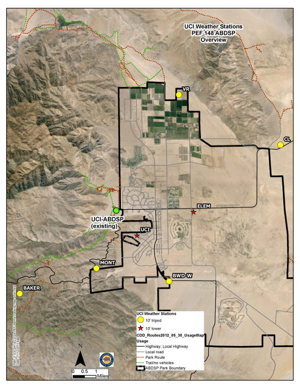
- Anza-Borrego State Park Headquarters Weather Station located at the Colorado District Office (2 dashboards to chose from):
- Elementary School weather station
- Wilcox Well weather station
- Viking Ranch weather station
- Clark Dry Lake weather station
- Dry Canyon weather station
- Culp Valley (Baker) weather station
Other weather stations in the park
San Felipe Valley Weather Station (Upper Sentenac Cienega)
Webcams or PhenoCams
View the pheno (web) cam archive for past images here:
http://sbabdrc.ess.uci.edu:81/
Research Center Base weather station webcam (looking west towards San Isidro mountains and Montezuma Grade):

Live image from base weather station

Live Phenocam image looking west at the ISEECI Research instruments: Ecophysiological Instruments for Measuring Biotic Climate Impacts Across Western Field Stations
Live InfraRed IR Phenocam image
NOAA/NWS Weather Data for Borrego Springs and Anza-Borrego Desert
- Local Borrego Springs National Weather Service Forecast
- UC Berkeley Dendra past weather data for Park Headquarters Weather Station (more stations from around Borrego will be added at a future date)
- Weather Data for Mobile Devices
- Air Quality Forecast
- Radar images (San Diego)
- Radar images (East and Imperial county)
- Satellite Imagery
- 100+ Degree days per year breakdown

Dark Sky Weather Forecast for Anza-Borrego Desert State Park
- Borrego Springs Clear Sky Chart This web site provides a forecast or prediction of when Borrego Springs, CA, will have good weather for astronomical observing.